
Introduction to gold indicators in Western Australia
As I have said before there is a big difference between some one who operates a metal detector and an actual prospector. A prospector can use his surroundings to figure out where the gold will be and work out how to optimise gold recovery. So understanding gold indicators will help you with this.
There are 100s of gold indicators, I cant talk about them all in one blog so instead I will break the gold indicator blogs in too parts.
GOLD INDICATORS
-
Geology
As we all know it is pretty important to understand the geology of your area if you want to figure out where the gold is. All areas are different, not just different states but even different Goldfields in the same state. For example the Kalgoorlie goldfields is very different from the Murchison goldfields. So you need to understand what is relevant for that area. There are definitely common indicators that are the same across most goldfields, for example deep red soil is a great indicator for gold as it means the ground has a high mineralisation which indicates the presence of iron and in return tells us it is gold bearing country (generally).
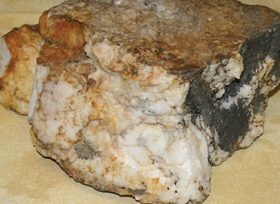
We all know that Quartz and Ironstone are two of the biggest gold carriers. We often look for "salt and pepper" ground (Ironstone and quartz scattered together) when we are looking for new ground. This is because the contact of the two is a great gold indicator. Below is a picture of a quartz and ironstone specie, something we always look for out bush.
Now although quartz and ironstone are two of the biggest gold indicators it doesn't mean that if they are present there is definitely gold. This is where figuring out what the gold is carrying in, in that area is very necessary. One of the easiest ways to do this is to study the alluvial (new and old) workings in that area. So look for the old boys shafts, Puddlers and dry blows and see what rock they were working in. If they have dug a bunch of shafts in a quartz wash that is a pretty good sign that the gold was carrying in the quartz in that area. Or if there is a heap of dry blows on the side of a laterite hill I would be targeting not only that hill but the other laterite hills in that area. If you come across some ones patch (obviously making sure it is an old one and they aren't currently working that area) and it is on an area of ironstone you can assume the gold is carrying in ironstone in that area.
Another way to identify this (not as easy) is when you find a specie or a nugget and it still has some matrix attached. This is a great way to tell what the gold is carrying in.
Once you have this identified you can start to target the correct areas and follow the geology in the right direction. This can be a broad indicator as there might be a large area of the gold carrying rock so you can use this in conjunction with other indicators to narrow it down.
Another point to note on this subject is that the size of rocks in a wash can be an indicator for the size of gold. If there is a wash of tiny small rocks you will generally find small fine gold. Wash with bigger mixed sizes of rocks generally carry the bigger nuggets.
-
Modern workings
So we often talk about using old timers workings to identify gold bearing areas but modern workings can give us a lot of useful information as well!
As I talked about before we can use dig holes (where a person using a metal detector has dug) to identify what geology the gold is carrying in. If we see a bunch of dig holes on the side of an ironstone hill not only would you target that hill but also the other ironstone hills in that area.
Dig holes can also help determine the depth of the ground. If you notice a few dig holes in an area that are all quite deep you can assume that the gold in that area is running deep. I would then pop on a bigger coil and make sure your gain isn't too low.
If there is a group of dig holes that are quite old I would try the area again because remember technology has improved a lot over the years. Also if they are on the side of a hill it would be worth popping on a bigger coil and trying below them to see if they have missed the deeper bigger nuggets.
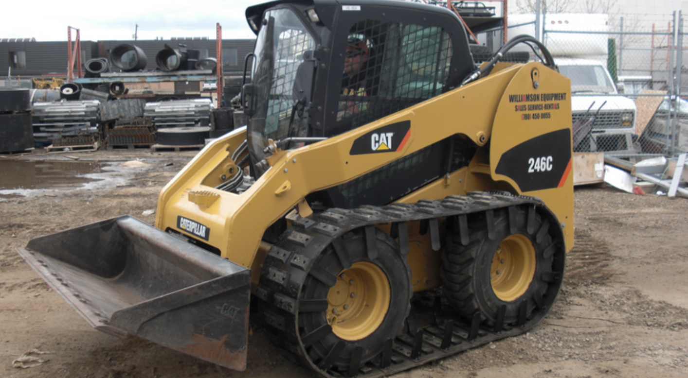
Bob cats were used in the goldfields in conjunction with VLF detectors. They arent used any more because our pulse induction detectors can detect deeper than a bobcat can push so there is no point. This is useful information because if you come across bob cat pushing's you know the area was detected with a VLF machine (assuming some one hasn't gone over it afterwards) so its definitely worth going over your pulse induction. Bobcat tracks are very small compared to a loader! This is the size of the bucket for reference.
Open cut mines are quite common in the WA gold fields and can offer some useful information. Although this type of mining chases a different type of gold to what we chase it is definitely worth detecting the surrounding areas, especially if there is any creeks running off the mine. The creeks would be worth panning as well. The area is obviously gold bearing if they have decided to mine it so its worth a go.
Certain rules in different states make this difficult and I know there is a lot of land in VIC tied up on private land but this is something to keep in mind. If you come across pushing's the surrounding ground (if you have access) is definitely worth detecting. It will also help to identify what geology the gold is carrying in that area. Work the edges, above and below most of the time the workings don't stop because the gold did but because of the regulations around how much space you can work and how much ground you can push!
-
Contact points
Being able to identify geological contact points is very important (and often overlooked) by prospectors for finding areas that gold will occur. Basically this is an area where two different rock types come together.Its great to figure out what the gold is carrying in but it also super useful to figure where the different rock types are contacting. What is most important is that some type of contact occurred, which created pressure and often extremely high temperatures which caused fissures to form and gold to be pushed up to the surface. Once the gold is pushed to the surface it will then follow the easiest path in which ever direction that may be.
To keep it simple, I will just say that identifying these areas where different rock types came together are often extremely important. This is a massive subject and I could get into the geology of this but I think I will leave that for another session. For now you just need to know that Identifying these contact points is important.
Look for contact points where different rock types come together at a 90 degree angle. These contacts resulted in high pressure and high temperature conditions that would commonly produce gold. Youll find the old boys targetted these areas as well.
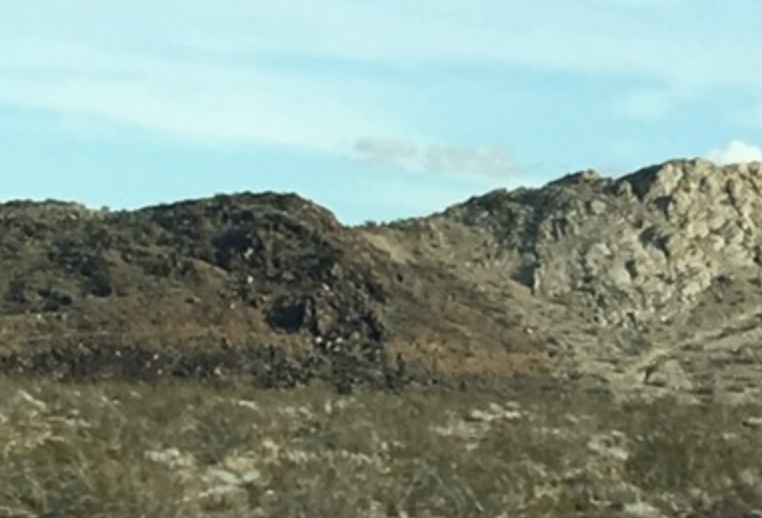
Some contact zones are very clear to the eye and others are harder to see, especially in areas like VIC and NSW where the ground is covered in foliage. Below is a picture of a very obvious conact zone that you can spot whilst out on the field.
A great way to find contact zones is to use maps. We get our printed maps (so we can take them out bush) from the mines department and from our local detector shop (Finders Keepers) A lot of local detector shops have the local areas maps so you can always ring and ask :) Below I have linked some websites where you can access the maps for most states. All the websites provide online access but you can always call/email them if you need help or you want physical maps.
WA - http://dmp.wa.gov.au/
NSW - https://resourcesandgeoscience.nsw.gov.au/miners-and-explorers/geoscience-information/geological-survey-of-nsw/geological-mapping
VIC - https://djpr.vic.gov.au/what-we-do/mining-and-resources
SA - http://www.energymining.sa.gov.au/mineral_resources
QLD - https://www.business.qld.gov.au/industries/mining-energy-water/resources/minerals-coal/online-services/minesonlinemaps
-
Drill holes
Alright so with drill holes the type we are looking for a called RC drill holes and they look like this -
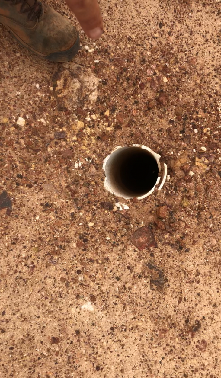
They are collard with the pipe and easy to spot if you are looking for them. They are extremely expensive companies to do and they must be serious about the area if they are spending that much money. What we are looking at though is the direction on the drill hole. The drillers will drill through the source they are looking for so they can get a clear picture of all the layers. So if the drill hole is running north to south we know that what they are looking for is running east west. I would then head to the east and west of the drill hole to see if I can pick up any alluvial nuggets.
Like always if you have any questions please ask.
Tyler